Showing posts with label Wainwright. Show all posts

Friday, 9 December 2011

Robin Hood's Bay, North Yorkshire

Robin Hood's Bay
Robin Hood's Bay is unusually both a Bay and a small fishing village on the North Yorkshire coast. Although the village has now extended up the hill where the car parks and larger accommodation are located, the main focus of attention is on the separate historic area at the bottom of the steep lanes.

Door Knocker, Robin Hood's Bay
It's lifeblood seems to originate from events of the sea and walking around the village, I always get the feeling that it is a place that is full of smuggling history.

Roofs, Robin Hood's Bay
Sailing back into history though, there's not a lot to find specifically about Robin Hood's Bay beyond the 15th century.


Legend suggests that the name comes from Robin Hood rescuing the local people from the French pirates who came to steal their boats and returning the assets to the people of the village.

Chapel Street, Robin Hoods Bay
It might be unbelievable but then again as I take you on a walk around the village, everything is unbelievable.


Fishing and ... err .. smuggling (an 18th century tax evasion haven as it imported goods such as tea, tobacco and rum from mainland Europe) were the main industry but the geography of the village would be a determining factor as to why the former declined in the 19th century and the latter succeeded !


Whole families would be involved in the fishing industry by part owning a small boat or transporting the goods to other parts of Yorkshire for sale.

A short distance to the north, Whitby has a more accessible harbour and the fishing business still survives to this day.


Following a comment in the section below, I decided to revise the above image to straighten the verticals when I acquired the relevant program and expertise...

Old Post Office, Robin Hood's Bay
In order not to tantalise you with art and photography, here are a few photos that depict the village

Old Bakery Tearooms, Robin Hood's Bay
The Old bakery tearooms overhanging the river with it's wooden extension.


Robin Hood's Bay House

The most recognised house in the village (title photo) seen here from a slightly different angle.


Tourism is the main industry these days for those who enjoy the romantic images of fishing villages from the past, artists and ... err ... photographers !

New Life !!

Onwards and Upwards !

Guest House    (Bramblewick Robin Hood's Bay)
An author called Leo Walmsley used the village as a picturesque location of his Bramblewick books.

Muir Lea Stores, Robin Hoods Bay
The village shop that seems to sell everything in all seasons !!

(Coast to coast walk, Robin Hood's Bay)
Alfred Wainwright, the famous Lake District writer, artist and fellwalker, moved on to other projects later in life. One of which was to design a walk that went through glorious countryside across Northern England. The route which can be done in either direction goes through three National parks (Lake District, Yorkshire Dales and North York Moors) but the favoured route is west to east where the walker has to dip their feet into the north sea to complete the walk ...


Tide watch !!

Happy sailor in a window box !


I realise that I've missed a whole season out but I'm reminded that I must get those Christmas cards written for posting next as I don't want to be left out in the cold ....


Sunday, 15 August 2010

Blea Rigg and Easedale tarn


Blea Rigg is a mixture of crag and summit on a linear style upland plateau stretching from Grasmere to the Langdale Pikes. The above view is the most appropriate photograph of the fell taken from Easedale tarn. The final stages of the ascent was up the left hand side to the summit in the centre.

This was a difficult day to judge for a number of reasons. There was heavy rain during the morning and it was difficult to see anything of the hills at all, far less photograph them. As a tourist, I do not mind using a certain car park in Grasmere, but as a walker, I use a different place on the main road which tends to fill up early. As I arrived in early afternoon, there were no spaces left and I had to park a reasonable distance away from the start of the walk outside someones house on the main road further up towards Dunmail raise. Although I didn't mind the extension to the walk, the clouds did nothing for the results in the photographs and in a sense, I considered leaving this post out as this was the only one that I have had to motivate myself with so far. The walkers amongst you will be happy enough with the pictures but I have had to add a bit more text for the photographers and tourists amongst you as I realise that the pictures may not stimulate everyone.

Sour Milk Gill waterfall and Brimmer Head farm
The start of this walk is usually from Easedale road beside the Heaton Cooper Art studio, although I joined the official route a little way further on. Once leaving the road, I was greeted with the above view with the path going up the left hand side of the waterfall before disappearing around the lower crag to the left. William Wordsworth could apparently see this valley from Dove Cottage in Grasmere and named the view "the black quarter" due to the positioning of the sun and the resulting shadows....... very apt indeed I think, due to the lack of it today !!

Once around the corner and after a short walk, Easedale tarn is reached. This is the largest mountain lake in the Lake district at 480m x 300m and is enclosed in a three sided combe bordered by Tarn Crag to the north, Belles Knott to the west and this view from the slopes of Blea Rigg. Incidently, the view below was taken from the opposite direction as the first photograph in this set.


The last time I passed Easedale tarn, it was glorious sunshine and with the amount of people I saw by its shores as a final destination, there should have been an Ice cream van nearby!! You may find that comment rather amusing as you consider the steepness of the path adjacent to the waterfall, but there was a time in the past when a local entrepreneur had an eye for business. There was a small stone refreshment hut beside these shores that drinks were served from. One of the things that had to be maintained was the path past the waterfall in order that he may attract regular customers and it is said that he carried a boat up for hire on the Lake too !! The business eventually closed and souvenir hunters collected pieces of the property over a period of time before a team of volunteers were assigned to dismantle the unsafe structure.


On reaching the summit, the eye is drawn to the south where Windermere, the largest lake, is seen. Langdale valley commences in the foreground heading to the right with Elterwater also viewed in this shot.


The tension of sunshine and cloud is shown above at the summit area with The higher Bowfell in the distance on the left being in cloud rather than the lower and more famous Langdale Pikes on the right.
The photo below depicts the three longitudinal hill ranges coming from the Central Fells area all pointing towards and ending at different stages in the direction of Grasmere......


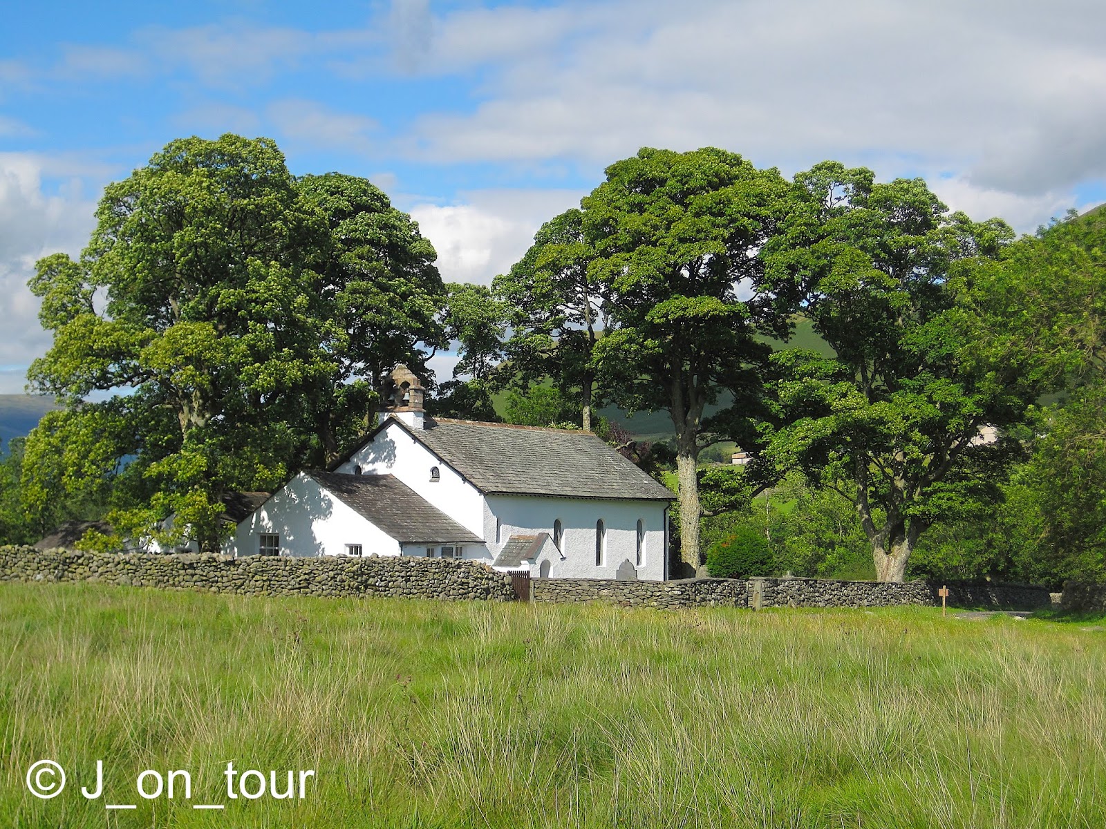
...... Front to back : Tarn Crag, Calf Crag to Helm Crag range, Steel Fell and Helvellyn in cloud in the rear. After following an interesting path around small tarns and rocky outcrops along the undulating top in the Grasmere direction, it was time to descend down into Easedale valley. My destination was the large white building just to the left of centre.....


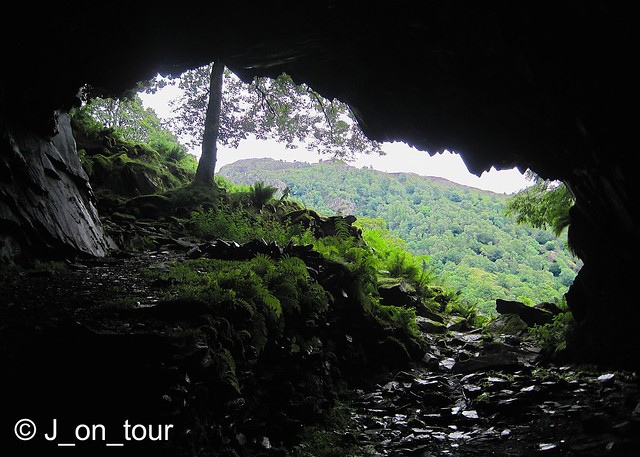
I felt that this album was more of a walking journal that lacked a bit of colour, so I managed to capture something that might seem out of place on the way down...


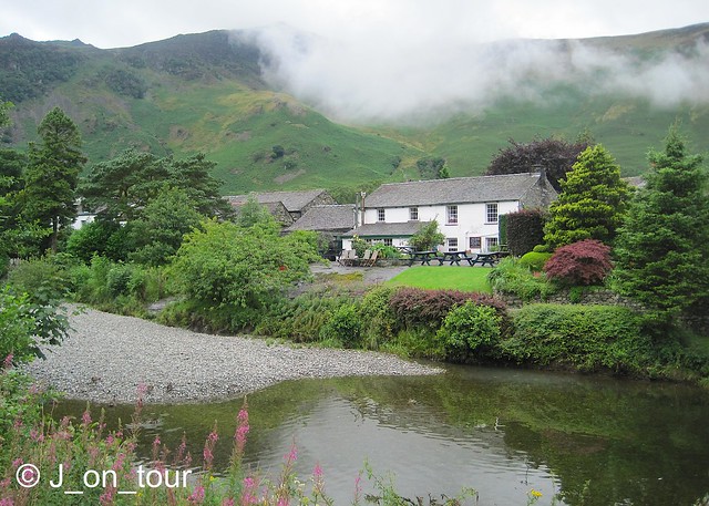
There were more conventional opportunities for Lake district scenes on the valley floor....


.... and a customary piece of humour from myself to finish with. This may seem like a blot on the picturesque landscape but farmers look after their sheep by storing grass for the winter.....


so DON"T JUMP !! ..


Thursday, 12 August 2010

Ard Crags, Knott Rigg & a mountain rescue


A short drive from my accommodation took me on to the scenic Braithwaite to Buttermere road. My plan was to climb Ard Crags by the classical route from the road bend at Ard Beck Quarry as I had covered this hill before with some inexperienced walkers by an easier route from the opposite end. It is sometimes not possible to do this route as the quarry can only take about six cars. On arrival however, I was fortunate enough to take the last space, but there was an element of unease as I felt I was partially blocking access to a rack of stored insulation for the nearby "Grand designs" style house. Ten minutes into the walk, still worrying about the positioning of the car, I took the photograph above that represents as close as I can get to the pencil drawing that Alfred Wainwright drew on the title page of this fell in his Pictorial guide book 6. As I continued up Rigg Beck, the mountain profile and the route I would be taking became more evident across the stream, through the grass diagonally on the left, through the darker green bracken and joining the rounded ridge in heather.


Although heather can sometimes be thought of as a Scottish plant in origin, it is often found on lower Lakeland fells particularly in the north of the region.

On the slopes, leaving bracken, entering the heather


The day was interrupted by an unfortunate incident down on the Rigg Beck path requiring the need of the mountain rescue team and the subsequent use on the Great North Air ambulance. (The first is self funded and made up from a team of experienced volunteers, the second is a charity that owns two helicopters. As a point of interest, the organisation is currently trying to purchase a third helicopter once owned by Michael Owen the football player, when he used to travel from his Cheshire home to play for Newcastle United. Speaking as a Newcastle United fan, an expensive and unhappy time for the club!. The helicopter was also hired out for celebrity use ranging from politicians to music stars.)

"I'm sure I dropped the keys over here"
The above view was taken at the summit of Knott Rigg where the helicopter found a landing place looking towards the cloud over the Buttermere valley to the High Stile and Pillar group of fells. The use of the helicopter took over an hour while the casualty was being attended to and then it was time for me to descend the hill.
The balanced view below firstly depicts Derwentwater in the centre of the photograph with Ard Crags that i ascended on the left and Catbells, one of the more popular hills for views of Derwentwater on the right. In the distance on the left is the famous mountaineers destination, Blencathra, while the less famous and more rounded top of Clough head is on the right. The valley in between is one of the northern gateways to the Lakes by means of the A66 road to Penrith, which incidentally is where the helicopter used on this day is based.


Path through the heather,. then steeply down through the bracken ...


Car drivers going in the Braithwaite to Buttermere direction always know when they come to Keskadale farm because of the steep hill and hairpin bend on the road, it's an experience and a half to see what your car is capable of !! The working farm also has accommodation available and it may be worthwhile looking up their website at this stage because there is a photograph of where I am taken from the other side of Derwentwater........ Classical Lake district view.
On reaching the farm, I seemed to upset the pack of sheepdogs in their kennels and despite wanting to take a photograph of them, I felt it best to continue on as I was disturbing the peace in the valley !!
My journey continued along the path to the right just after the road bend through rights of way on farmland. By now, the sun started to shine at long last........


I had an opportunity to look back at my ascent route up Ard Crags from the other side of the hill...


I eventually came to Newlands church, much loved by artists and photographers. This whitewashed building was rebuilt on the original site in 1843 retaining some of its original internal 17th century features. William Wordsworth once wrote a poem about it in 1826 called "To May". There is also an adjacent restored schoolroom to the left of the building. Newlands church and its surroundings are a delight and a place of solitude..


...away from the passing "walking" traffic !!

Friday, 6 August 2010

Derwentwater, Borrowdale and Castle Crag.

Launch through the trees  GJC_IMG_6979 - Version 2
Keswick Launch, Derwentwater
Derwentwater is sometimes known as Queen of the English Lake District, Although it is by no means the largest, it is surrounded by some amazing scenic hills and mountains. A fleet of these boats,shown above, otherwise known as the Keswick launch have plied their trade for years using seven different landing stages around the Lake. After the disappointment of the weather from the previous post, the cloud started to lift so I thought I could squeeze in a short late afternoon walk. A drive to the south end of Derwentwater brought me to the picturesque village of Grange in Borrowdale.

River view cafe  GJC_IMG_6993
Grange Bridge Cottage Tearoom, Grange in Borrowdale
As an introduction to this walk, Alfred Wainwright was a walker who described 214 Lakeland mountains and hills in the seven "Pictorial guide(s) to the Lakeland Fells"during the 1950's and 60's. The books that are an amazing piece of artwork to hold by the viewer, are filled with hand drawn maps, ascent routes up the hills and neat handwriting. It is unbelievable to think that this project took him well over ten years to complete and without his own transport. Many people, including myself, use these guides on the hill alongside the map as they are so good and informative.
  As I was a bit short of time, I opted for Castle Crag which is the smallest of the 214 and just about three miles (4.8km) walk from Grange. The first third of the walk is on the flat and follows country lanes, the River Derwent and through some woods. The second section starts a gradual incline out of the woods and along side the hill to where the photograph below is taken. Derwentwater starts to come into view in the distance. This was the profile that Wainwright decided to draw on the title page of this hill in his Pictorial guide to the North Western Fells, book 6. I think you can imagine the detail of the Art with the rocks and scree. There wasn't as many trees then though when I compare this photograph with the book.

Castle Crag  GJC_IMG_7014
Castle Crag, Borrowdale
Also in the picture, the path of ascent can be noted and seems quite straightforward until the grassy section comes to an en end, and then I remember what Borrowdale is famous for...... it's slate. There's tons of the stuff here.

The slate climb  GJC_IMG_7024
The slate ascent, Castle Crag, Borrowdale
A zig zag path gives some airy viewpoint at the south end of the hill before the summit is reached with the north facing view of Derwentwater.


Dull view to Derwentwater   GJC_IMG_7042
Derwentwater from Castle Crag
The village of Grange is in the foreground with the route I took going around the group of trees on the left. Keswick is at the far end of Derwentwater just in front of the mountain Skiddaw (3054ft /931m). No chance of seeing the top of that today, unfortunately, thanks to the cloud.

The Way down  GJC_IMG_7057
The descent, Castle Crag
Time to descend again down, join the path just over the other side of the wall and circumnavigate Castle Crag in an anticlockwise direction. I was leading a walk, last time I was here, and didn't have time to take a diversion from the path to see a famous Lakeland cave. Millican Dalton was a hermit that used to live in this cave during the summer of the 1940's and earned his living as a walking guide to the largely unexplored territory at that time to most.

The Cave  GJC_IMG_7063
The Cave, Castle Crag
Once back on the main river path, it was a straightforward walk back to join the path I left on the outward journey. All too soon I was back in Grange where the teashop was about to close. No doubt, this is a place where people talk about the beauty and wonder  of the Lake District.

Way in for tea  GJC_IMG_7074
Grange Bridge Cottage Tearoom, Grange in Borrowdale
...but as I didn't have that kind of time, I just had to catch up with what the locals thought about it...

Sheep  GJC_IMG_7070
Borrowdale Sheep
The splendour of the short walk on my first day was amazing but the effort I had to put in,  ......... was nothing to write home about !!

Postbox  GJC_IMG_7072
Postbox, Grange in Borrowdale
Related Posts with Thumbnails